
Gypsy's Hole, Overton Scar
At the southernmost end of the Cheshire Sandstone Ridge and close to Malpas, there is an attractive sandstone outcrop, with splendid views to the west, known as Overton Scar. The strip of woodland that follows the length of this escarpment is smothered in bluebells in the spring and is easily visible from a footpath running parallel to Whitewood Lane. At the southern end of the escarpment, on early OS maps, is the site of a cave known as Gypsy's Hole.
In early histories of the county this is described as a site of some considerable interest. For example, in 1819 George Ormerod called it:
'a vast cavern, which until late years was celebrated as the haunt of a numerous tribe of gipsies. These visitants have been lately expelled by the hand of the law, in consequence of their frequent mal-practices in the neighbourhood; the cavern is inclosed sic, and plantations of firs and larches almost conceal its aperture'.
Ormerod probably drew his information from J.H. Hanshall who, in 1817, had described the same place with a little more detail:
'It is an immense projecting rock, rising to a considerable altitude, beneath which was the Cavern where the wanderers sheltered. They assembled here, sometimes in a band of sixty persons; and on one occasion they were actually relieved by the parish, during the inclemency of a severe winter. This humanity of the parishioners did not, however, meet with a suitable reward; and the vagrants being detected in some nefarious practices, they were prosecuted'.
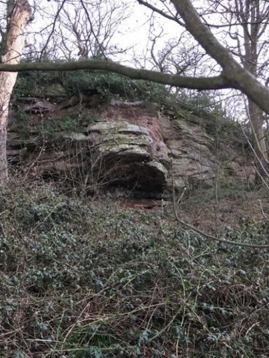
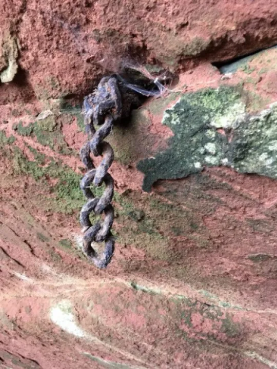
Today's visitor will be disappointed as no 'vast cavern' is currently visible, although the 'projecting rock' is plain enough (see photo 1 to the right). It is possible that the roof of the original cavern has collapsed and its remains lie in the foreground covered with debris. Alternatively, Ormerod's use of the word 'inclosed' may refer not to the surrounding plantation but to actual closure of the cave entrance or entrances. There are several possible locations for these where narrow horizontal cavities at the base seem to extend deeper under the rock. The area does not appear to have been much disturbed by trespassers, there has been some quarrying in places and an ancient dry-stone wall encloses the plantation. There is very little graffiti visible and only one small artefact has been observed: a strong chain stapled to the rock (see photo 2 to the right and below) possibly used for tethering a pony?. Excavation might reveal how the cavern was 'inclosed' but unfortunately it has proven difficult to track down the owner of this particular section of the scar so current access is not possible.
This has not proven, however, to be a block to some further research as, thanks to two of our indefatigable volunteers, we have discovered a little more about the 'wanderers' who lived in the cave at the end of the eighteenth century. In the Malpas parish registers there is an entry dated 29 September 1800 for the marriage of Thomas Florence and Sarah Hall, 'both from the Caves at Overton'. A note in the transcription of the register states that they were both illiterate, presumably because they signed with crosses. The date 1800 opens a window of time between then and 1817 when Hanshall says that the gypsies had been evicted and 1819 when Ormerod describes the site as 'inclosed'.
Thomas Florence was a travelling tinker, born in Belfast in about 1776, and he would have been 24 when he married Sarah whose age is unknown. It is not clear whether they left the caves immediately after their marriage or stayed in the vicinity for a while, but one of our volunteers has tracked down Sarah in 1807 to Witley, Surrey, where she was arrested and convicted at the Quarter Sessions of being 'a rogue and vagabond ... wandering abroad and lodging in the open air, with four children ... and not giving a good account of herself'. She was discharged but it is unclear what happened to her or her children, or whether Thomas remained with them.
By the early 1830s it would seem that Sarah had died as a Thomas Florence (widower, and brazier) is found in 1839 marrying another Sarah, Sarah Hudson, in Uttoxeter, Staffordshire. This couple appear in the 1841 Census, with Thomas (65) recorded as a "grinder", living on The Heath, Uttoxeter, with a family of five. The oldest two of the five, Nathaniel and George had been born outside the county and may have been later children of the first Sarah. Nathaniel (20) was a sweep and George (18) was a labourer. The remaining, much younger children, John (7), Thomas (9) and Sarah (10), had all be born in Staffordshire and may, therefore, have been children of the second Sarah, but not born in wedlock.
The Florences give us a glimpse of the lives of some of the poorest in society. Generally invisible in our written history, such people, who actually lived in the caves that we have been studying, make a welcome contribution to the spectrum of people who lived or made their living on the Ridge in the past.
We are indebted to David Haynes and to Mary Jones for their research into this topic.
Due to conservation risks and the inherent dangers of underground exploration, the Sandstone Ridge Trust does not support visits to any caves without the permission of the landowners and due attention to safety. We cannot accept responsibility for personal injury should anyone choose to explore caves on the Ridge.
A related article can be found in our Footprints on the Ridge section of the Website CLICK HERE.
{References:
1 George Ormerod, 1819, Vol II p.368
2 J.H. Hanshall, 1817. History of the County Palatine of Chester, pp 341,654
3 Parish registers for 1561-1812. Cheshire Archives & Local Studies, Ref. P 21/3607/3/5 (Microfilm 117/3)
covering Marriages for July 1800-December 1812.
4 Surrey Quarter Sessions 1780-1820, ref. QS2/6/1808/EPH/35.}

Sandstone Ridge Trust
Registered Company No. 7673603
Registered Charity No. 1144470
info@sandstoneridge.org.uk